
The Land Registry Hub: Your Go-To Guide for Property Plans & Conveyancing
🛠️ Navigating the world of Land Registry, lease plans, title plans, and conveyancing can feel like a legal maze—but don’t worry, we’ve got you covered! Whether you’re a property owner, landlord, solicitor, or just someone trying to make sense of UK property rules, this blog is your one-stop resource for clear, practical advice.
From understanding lease plans to avoiding common conveyancing pitfalls, we break it all down in a way that’s easy to follow. Stay tuned for expert insights, tips, and updates to keep you ahead in the property game! 🏡📜✨
Land Registry Compliant Plans
Common Mistakes When Preparing a Land Registry Lease Plan (And How to Avoid Them)
When it comes to property leases in the UK, getting your Land Registry lease plan right is non-negotiable. If it’s incorrect, incomplete, or doesn’t meet the Land Registry’s requirements, you could face delays, extra costs, or even a rejected application.
But don’t worry! In this guide, we’ll walk you through the most common mistakes people make when preparing a lease plan—and, more importantly, how to avoid them.
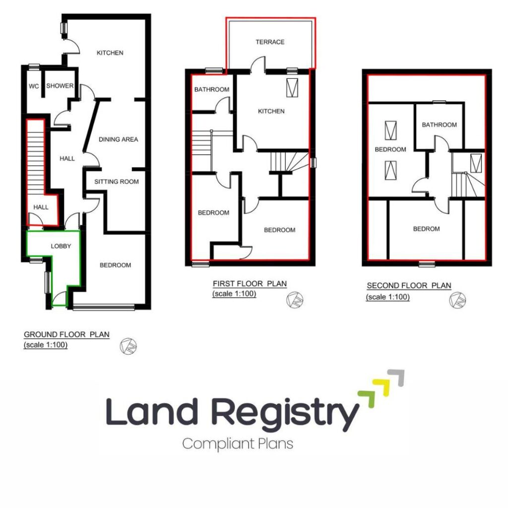
What is a Land Registry Lease Plan? (Quick Recap)
A Land Registry lease plan is a scaled drawing that outlines the exact area of a property being leased, along with any shared spaces, access routes, and rights of way. It’s required when:
📌 You’re granting a lease of 7 years or more
📌 An existing lease is being registered for the first time
📌 You’re making major changes to a lease (such as adding or removing space)
Lease plans must be accurate, clear, and compliant with the Land Registry’s guidelines. If not, your application could be delayed or rejected.
Common Mistakes That Can Get Your Lease Plan Rejected
Even small errors in a lease plan can cause big problems down the line. Here are the top mistakes people make—and how you can avoid them.
🚨 Mistake 1: Incorrect or Missing Boundaries
The problem:
One of the biggest reasons lease plans get rejected is because the boundaries aren’t correctly marked. If the plan doesn’t clearly show which areas belong to the tenant and which are shared, it won’t be accepted.
How to avoid it:
✅ Clearly outline the demised (leased) area in red
✅ Show any shared access areas (e.g., hallways, driveways)
✅ Double-check that the boundaries match the lease agreement
🚨 Mistake 2: Using the Wrong Scale
The problem:
The Land Registry has specific scale requirements for lease plans. If your plan isn’t drawn to scale, it won’t be accepted.
How to avoid it:
✅ Use the correct scale:
- 1:1250 for urban properties
- 1:2500 for rural properties
✅ Make sure the scale is clearly stated on the plan
✅ Double-check that all measurements are accurate
🚨 Mistake 3: No North Point
The problem:
A lease plan must show a north point so that the orientation of the property is clear. If it’s missing, your plan could be rejected.
How to avoid it:
✅ Always include a north arrow on your lease plan
✅ Ensure it points in the correct direction
🚨 Mistake 4: Not Using Ordnance Survey (OS) Mapping
The problem:
Lease plans should be based on Ordnance Survey (OS) mapping to ensure accuracy. If they aren’t, they might not align with Land Registry records.
How to avoid it:
✅ Use an up-to-date Ordnance Survey base map
✅ Ensure the plan matches the surrounding properties and streets
🚨 Mistake 5: Missing Shared Access and Rights of Way
The problem:
If the tenant has access to shared spaces, such as a communal garden, driveway, or entrance hall, these must be clearly marked.
How to avoid it:
✅ Show all shared areas on the plan
✅ Use a different colour or shading to highlight them
✅ Label any public rights of way or private access routes
🚨 Mistake 6: Poor-Quality or Illegible Plans
The problem:
If a lease plan is blurry, hand-drawn, or missing key details, it won’t be accepted.
How to avoid it:
✅ Make sure the plan is high-resolution and professionally drawn
✅ Use clear labels and consistent line thickness
✅ Print the plan in A4 or A3 size for easy reading
🚨 Mistake 7: Failing to Match the Lease Agreement
The problem:
Your lease plan must match exactly what’s stated in the lease agreement. If there are inconsistencies, the Land Registry may flag an issue or reject the plan.
How to avoid it:
✅ Cross-check the lease agreement and the plan before submission
✅ Ensure all measurements and descriptions align with the lease terms
✅ If changes are made, update both the lease and the plan
🚨 Mistake 8: Not Highlighting Exclusive and Non-Exclusive Areas
The problem:
Some properties have areas that are exclusive to the tenant and others that are shared. If these aren’t clearly marked, the lease plan could be rejected.
How to avoid it:
✅ Highlight exclusive areas in red
✅ Show shared or communal areas in a different colour (e.g., blue or green)
✅ Clearly label each section on the plan
How to Ensure Your Lease Plan is 100% Compliant
To avoid these common mistakes and get it right the first time, follow these best practices:
✔️ Hire a Professional – A chartered surveyor or specialist lease plan provider can ensure the plan meets all Land Registry requirements.
✔️ Double-Check Boundaries – Make sure the leased area matches the lease agreement exactly.
✔️ Use the Right Scale – Stick to 1:1250 or 1:2500, and clearly state the scale on the plan.
✔️ Include All Key Features – Boundaries, rights of way, shared spaces, north point—don’t leave anything out!
✔️ Submit in the Right Format – Use high-resolution PDF or printed copies, with all lines and labels clear and legible.
What to Do If Your Lease Plan is Rejected?
If the Land Registry rejects your lease plan, don’t panic—most issues can be fixed quickly.
🔍 Step 1: Identify the Problem – The rejection notice will tell you why the plan was rejected.
📞 Step 2: Consult a Professional – A surveying or lease plan expert can help you correct the errors.
📝 Step 3: Make the Necessary Changes – Ensure the updated plan meets Land Registry requirements.
📩 Step 4: Resubmit the Plan – Once everything is fixed, send it back for approval.
Final Thoughts: Get It Right the First Time!
A Land Registry lease plan might seem like a small part of a property transaction, but getting it wrong can lead to delays, extra costs, and legal headaches.
By avoiding common mistakes—like missing boundaries, using the wrong scale, or forgetting to include shared spaces—you can ensure your lease plan is accepted without any issues.
Need a lease plan? Speak to a professional surveyor or lease plan provider to make sure everything is 100% Land Registry compliant.
💬 Got questions about lease plans? Drop them in the comments—we’re happy to help! 🏡📜✨

Contact Us
Call Us : 01375 267 277
We are open from Monday to Friday
08.30 AM - 17.30 PM
Surv Essex Limited
Building 13 Thames Enterprise Centre
Princess Margaret Road
East Tilbury
RM18 8RH
Our Services
- Lease Plans
- Title Plans
- Conveyancing Plans
- Licencing Plans
- Retail Plans
Quick Links
- Home
- About Us
- Pricing Plan
- Team
- Blog
- Privacy Policy
- Terms & Service