The Land Registry Hub: Your Go-To Guide for Property Plans & Conveyancing
🛠️ Navigating the world of Land Registry, lease plans, title plans, and conveyancing can feel like a legal maze—but don’t worry, we’ve got you covered! Whether you’re a property owner, landlord, solicitor, or just someone trying to make sense of UK property rules, this blog is your one-stop resource for clear, practical advice.
From understanding lease plans to avoiding common conveyancing pitfalls, we break it all down in a way that’s easy to follow. Stay tuned for expert insights, tips, and updates to keep you ahead in the property game! 🏡📜✨
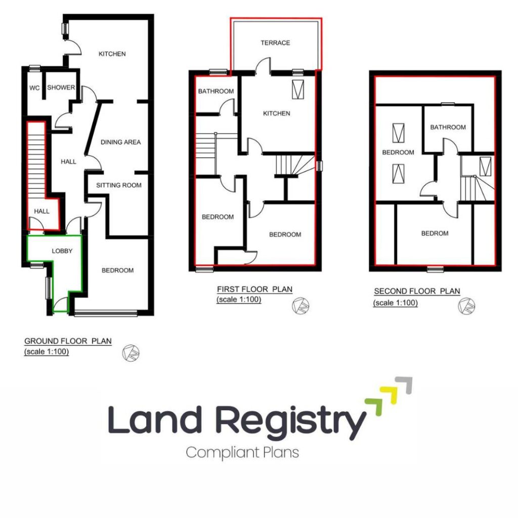
Land Registry Compliant Plans
Digital Mapping and the Future of Land Registry Plans in the UK
For decades, property boundaries and land ownership in the UK have been recorded using paper maps and traditional surveying techniques. But times are changing.
With advancements in digital mapping, Geographic Information Systems (GIS), and 3D property modelling, the way we create, store, and manage Land Registry plans is evolving.
So, what does this mean for homeowners, property developers, solicitors, and surveyors? Let’s explore how digital mapping is reshaping the future of Land Registry plans—and why it matters to you.
What is Digital Mapping?
Digital mapping is the use of electronic, computer-generated maps to accurately represent land, buildings, and property boundaries. Unlike traditional paper maps, digital maps can be:
📍 Updated in real time
📍 Overlaid with additional property data (e.g., ownership details, planning restrictions)
📍 Integrated with GPS for pinpoint accuracy
📍 Easily accessible online through Land Registry services
Why is this important? Because digital mapping is making land ownership records more precise, accessible, and reliable than ever before.
How Digital Mapping is Changing Land Registry Plans
1️⃣ Improved Accuracy & Boundary Definition
One of the biggest criticisms of traditional Land Registry Title Plans is that they show only general boundaries, not precise legal boundaries.
With digital mapping and high-resolution aerial imagery, property boundaries can now be mapped with:
✅ Centimetre-level accuracy using GPS and satellite data
✅ Real-time updates when boundaries change
✅ Integration with Ordnance Survey (OS) data to ensure legal compliance
🚀 Future impact: This could mean fewer boundary disputes and a more transparent land registration process.
2️⃣ Faster & More Efficient Property Transactions
The days of requesting paper copies of Title Plans are numbered. The Land Registry is shifting towards:
📌 Online access to all property records
📌 Instant digital submission of lease and title plans
📌 Automated checks for compliance with Land Registry standards
This means:
🔹 Quicker property sales and leases
🔹 Less risk of errors or rejected applications
🔹 Faster updates when land is subdivided or reallocated
📢 Did you know? HM Land Registry’s Digital Street project is working on a system where property ownership changes could be recorded in seconds, rather than weeks or months.
3️⃣ Integration with 3D Property & Land Models
Imagine being able to view a 3D model of a property’s boundaries, height, and layout before buying it.
With advances in Building Information Modelling (BIM) and GIS, digital mapping is allowing:
🏢 3D models of leasehold flats and shared spaces
🌍 Interactive land ownership maps
📊 Better visualisation of planning restrictions & easements
🚀 Future impact: This could make buying and leasing properties more transparent, reducing legal uncertainty about who owns what.
4️⃣ The Rise of Blockchain for Land Registration
One of the biggest challenges in land registration is fraud and outdated records. That’s where blockchain technology could come in.
🔗 Blockchain is a secure, tamper-proof digital ledger that could allow property transactions to be recorded instantly and permanently.
Potential benefits:
✅ Reduced risk of land fraud
✅ Faster property transfers without solicitors
✅ Clearer records of ownership and historical changes
📢 Did you know? HM Land Registry is already testing blockchain through the Digital Street project, aiming to simplify property transactions and increase security.
5️⃣ Smart Contracts & Automated Land Transactions
With digital mapping and blockchain, we could see the rise of “smart contracts”—automated agreements that execute when conditions are met.
For example:
🔹 A lease agreement could be recorded on blockchain, automatically triggering rental payments.
🔹 A property sale could complete instantly once funds are received, with ownership transferring digitally.
🔹 Title and lease plans could be automatically updated when land is subdivided or extended.
🚀 Future impact: This could mean less paperwork, fewer legal disputes, and a much faster buying & leasing process.
Challenges of Digital Mapping in Land Registry Plans
While digital mapping has huge potential, there are still challenges:
🔴 Accuracy concerns – GPS and satellite data aren’t always perfect, so errors could still occur.
🔴 Data security risks – Moving land records online means stronger cybersecurity is needed.
🔴 Legal updates required – Current UK property laws don’t fully account for blockchain-based land registration yet.
However, with ongoing improvements, these challenges are likely to be resolved in the coming years.
What This Means for Homeowners, Landlords & Developers
💡 If you’re a property owner:
✔️ You’ll have easier access to Land Registry plans online.
✔️ Boundary disputes could be resolved faster with accurate digital data.
💡 If you’re a landlord or tenant:
✔️ Lease plans could soon be digitally submitted and approved instantly.
✔️ Shared ownership and rights of way could be more clearly mapped.
💡 If you’re a developer or investor:
✔️ Digital mapping makes it easier to track land ownership.
✔️ 3D land models could help in planning applications and property developments.
Final Thoughts: The Future is Digital
The UK Land Registry is undergoing a digital transformation, and property mapping is at the heart of it.
✅ More accurate property plans
✅ Faster transactions & fewer disputes
✅ A move towards blockchain-based land registration
📢 What’s next? Over the next decade, we could see a fully digital Land Registry, with instant property transfers, 3D boundary models, and automated smart contracts.
💬 What do you think about the future of digital mapping for UK property? Drop a comment below! 🚀🏡📍
Contact Us
Call Us : 01375 267 277
We are open from Monday to Friday
08.30 AM - 17.30 PM
Surv Essex Limited
Building 13 Thames Enterprise Centre
Princess Margaret Road
East Tilbury
RM18 8RH
Our Services
- Lease Plans
- Title Plans
- Conveyancing Plans
- Licencing Plans
- Retail Plans
Quick Links
- Home
- About Us
- Pricing Plan
- Team
- Blog
- Privacy Policy
- Terms & Service